

Projects

Lake Rosemound Dredging and Restoration Plan
Project Status: Services Provided:
Design Coastal Engineering
Project Type: Planning
Lake Restoration/Dredging Dredging Design
Project Size: Cost Estimating
200 Acres Wetland Delineation
Project Description
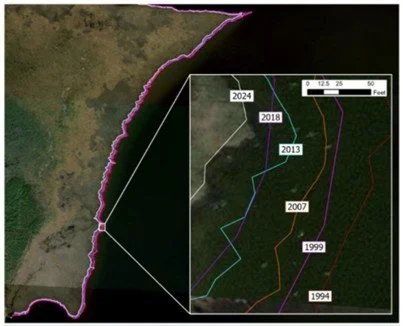
In 2023, The Lake Rosemound Association contracted SSE to develop a restoration plan to maintain sustainability of the lake. Lake Rosemound continues to experience sedimentation due to natural and anthropogenic causes such as severe storm impacts, adjacent logging, and altered hydrology. SSE is developing an incremental plan to target environmental and societal benefits desired by the client. The preferred alternative will move to final design. After completing the design phase, SSE will develop lake restoration construction plans and specifications and manage construction.

QuickReef® Engineering Analysis and Numerical Modeling
Project Status: Services Provided:
Completed Coastal Engineering
Project Type: Living Shoreline Design
Living Shoreline Shoreline Stabilization
Project Location: Numerical Modeling
Multiple Locations/Atlantic Physical Modeling
Coast
Project Description
In 2023, Native Shorelines, a Davey Company, contracted SSE to conduct engineering analyses along the Atlantic coast of North Carolina to site Quick Reef structures. SSE evaluated wind and wave conditions as well as local tidal datums to optimize design. A wave flume physical modeling study was performed on three designs at the University of South Alabama Living Shorelines Laboratory, to measure wave transmission attenuation, wave reflection, and structural stability. SSE performed computational fluid dynamics modeling via FLOW3D on numerous design variations to evaluate wave attenuation capabilities of the structures after calibrating the numerical model based on physical modeling results.

Lincoln Beach Restoration Project
Project Status: Services Provided:
Preliminary Design Coastal Engineering
Project Type: Environmental Permitting
Coastal Restoration/ Habitat Delineation
Development
Project Size:
27 acre beach/dune
Offshore breakwaters
Project Description
Lincoln Beach is situated along Lake Pontchartrain in New Orleans and was once a vibrant and cherished destination for waterfront recreation. Over time, this historic site experienced prolonged public closure and disinvestment, leaving it underutilized. The City of New Orleans plans to redevelop the site into a resilient waterfront destination. SSE is leading coastal engineering and design, environmental permitting and planning, and environmental surveying.

Living Shorelines Monitoring Study - Bogue Sound, North Carolina
Project Status: Services Provided:
Complete Wave Gauge Deployment
Project Type: Data Analysis
Wave Attenuation Monitoring
Shoreline Response Monitoring
Project Description
The first phase of a quantitative study of field performance of 4 living shoreline designs in Bogue Sound, North Carolina was completed in early 2025 (oyster shell bags, rubble mound, QuickReef(R), Oyster Catcher). Wave attenuation was monitored in the field with Feather Wave Gauges. Data was compiled and analyzed to determine each structure’s ability to dissipate wave energy. Average wave transmission coefficients were determined for each living shoreline technology. In addition, 3D photogrammetry was collected to assess oyster spat recruitment and quantitatively evaluate marine ecosystem development over time.

Golden Triangle Marsh Creation Project
Project Status: Services Provided:
Complete Coastal Engineering
Project Type: Conveyance Corridor Design
Marsh Creation Shoreline Stabilization
Project Location: Flood-Risk Reduction
SE Louisiana Construction S&I
Project Description
The Golden Triangle is a narrow band of brackish marsh located directly east of New Orleans. These wetlands are an important natural buffer, one of the multiple lines of defense protecting vulnerable communities in and around the city of New Orleans from storm surge. This area has suffered from accelerated land loss due to sediment starvation due to preclusion of annual Mississippi River flood events, natural subsidence, as well as accelerated subsidence due to oil and gas exploration. The Coastal Protection and Restoration Authority (CPRA) requested engineering and construction administration/inspection services for the Golden Triangle Project. The project goals are to restore and protect wetland, fish, and wildlife habitats, restore degraded marsh and reduce wave/wake erosion, and maintain landscape integrity and enhance community resilience to flooding and extreme storm events.
To design wetland features such as marsh, waterfowl habitat, and shoreline fortification, borrow sources including Lake Borgne, the Mississippi River, and Lake Pontchartrain were considered for dredging. Upon evaluating sediment conveyance corridor alternatives, a borrow area was designed in Lake Borgne that minimized impacts to shoreline morphology, dissolved oxygen concentrations in the lake, and nearby oyster and sturgeon habitat. Subaqueous hazards and critical habitat were surveyed and delineated, and features were designed to avoid impacts to these areas. SSE collaborated closely with CPRA and landowners to develop multiple wetland design features. Together, these features generate ecological synergies and provide geomorphic stabilization.

Bayou Dularge Ridge, Marsh, and Hydrologic Restoration
Project Status: Services Provided:
Complete Coastal Engineering
Project Type: Conveyance Corridor Design
Marsh/Ridge Creation Borrow Area Design
Project Size: Flood-Risk Reduction
629 Acres/Over 4MCY Shoreline Stabilization
Project Description
In 2020, Sigma Consulting Group, Inc. subcontracted SSE for engineering and design services for the Bayou Dularge Ridge, Marsh, and Hydrologic Restoration Project. Wetland loss and ecosystem degradation in the project area have been caused by subsidence, erosion, channelization, saltwater intrusion, and storm damage.
SSE’s role was leading dredging and equipment access design as well as performing independent technical review of marsh and coastal ridge habitat features. Funded by the RESTORE Act, the project proposes to use borrow material from Lake Mechant to create and nourish 630 acres of marsh on the south side of Bayou Dularge, restore 21,500 linear feet of ridge along the southern bank of Bayou Dularge, and reestablish historic hydrologic and salinity conditions by installing a structure that reduces the cross-sectional area and flow through Grand Pass and the saltwater intrusion into the project area.

Grand Pass Shoreline Stabilization Project
Project Status: Services Provided:
Complete Coastal Engineering
Project Type: Scour Apron Design
Shoreline Protection Shoreline Protection
Project Size: Channel Stabilization
0.83 Miles Shoreline Stabilization
Project Description
In 2021, SSE was subcontracted for engineering and design services for the Grand Pass Shoreline Stabilization Project. A hydraulic control structure was proposed for Grand Pass to reduce salt water intrusion north of the pass. Modeling results showed potential for scour along the adjacent shoreline and at the base of the structure.
SSE led the design of shoreline protection features to minimize impacts of the structure installation. Shoreline protection features included gabions and riprap for shoreline stabilization along Grand Pass. In addition, a scour apron was designed to protect the toe of the hydraulic control structure from scour. The goal of the Grand Pass Hydraulic Control Structure is to reestablish historic hydrologic and salinity conditions by installing a structure that reduces the cross-sectional area and flow through Grand Pass and the saltwater intrusion into the project area.

Proctor Point Marsh Creation and Shoreline Stabilization Feasibility Study
Project Status: Services Provided:
Complete Coastal Engineering
Project Type: Marsh Design
Marsh Creation Vegetation Classification
Shoreline Protection Shoreline Protection
Project Size: Land / Water Analysis
1,000 Acres Preliminary Cost Estimate
Project Description
In 2021, SSE was contracted by Restoration Systems to conduct a feasibility study for the Proctor Point Marsh Creation and Shoreline Stabilization Project. The purpose of this study is to evaluate the feasibility and conceptual cost of Proctor Point marsh enhancement via hydraulic dredging coupled with shoreline protection.
SSE evaluated the feasibility of multiple marsh creation areas and borrow areas throughout Proctor Point and Lake Borgne. Marsh creation area alternatives were proposed along Proctor Point and consisted of approximately 1,000 acre areas. In addition, approximately 16,500 LNFT of shoreline protection features were recommended along the Proctor Point shoreline. The Proctor Point wetlands are an important natural buffer that is one of the multiple lines of defense protecting vulnerable communities in and around the city of New Orleans from storm surge. It is one of the last remaining marsh areas adjacent to Lake Pontchartrain and Lake Borgne. The Proctor Point wetlands consist of brackish and saline marshes and serve as valuable habitat for wildlife, fish, and shellfish.
Upper Perdido Bay - Restoration Engineering for Lillian Swamp and Bronson Field Shorelines
Project Status: Services Provided:
Planning Alternatives Development
Project Type: Coastal Process Evaluation
Shoreline Stabilization
Project Area:
Alabama/Florida
Project Description
The project team performed a desktop study of environmental documents, field studies, and numerical modeling results to develop design alternatives for habitat-friendly shoreline stabilization measures along the Lillian Swamp Forever Wild Complex at the mouth of the Perdido River, including marsh enhancement, ecosystem restoration, and living shorelines. Alternatives development for Bronson Field, Florida, including site improvements, habitat-friendly shoreline stabilization, and hydraulic connectivity restoration is ongoing.